July 27 CFD

July 27
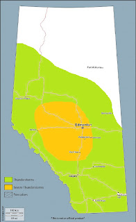
***A risk of severe thunderstorms will exist over much of westcentral Alberta on Thursday, with significant severe hail and damaging wind gusts possible in the late afternoon and early evening***
Discussion:
Moderate to strong SW flow aloft will exist over the province on Thursday, with subtle height falls ahead of a somewhat weak shortwave trough that passes through during the evening. At the surface, a weak lead wave that tracks over northern Alberta brings a weak cold front to the Elbow that slides southeast and stalls along the central foothills in the afternoon. Further to the south, a lee low develops northwest of Calgary, with hot, dry downslope flow across southern Alberta.
As of Wednesday evening, a pool of mid-teen dewpoints exists over parts of westcentral and northcentral Alberta, with the 00Z WSE RAOB revealing somewhat of a skin layer of richer moisture – however, the depth of low level moisture sampled overall isn’t insignificant. The associated surface ridge behind the front tomorrow will help drive this moisture into the central and northern foothills and into the northern side of the frontal boundary during the afternoon. Air wrapping cyclonically around the northern side of the surface low will be warmer and drier as it originates from southern Alberta. North of the boundary and across much of central Alberta, MLCAPE values near 2000J/kg will develop in the moist air with daytime heating. 0-6km shear values in this area will be in the 45-50 knots range – and coupled with 0-3km SRH values near 250J/kg, strong updraft rotation will be possible in a few discrete supercells. This will lead to a threat of hail up to the size of baseballs, along with damaging wind gusts. Environmental shear in the lowest levels (0-1km layer) will be very weak, however it will be locally enhanced in the vicinity of the west to east boundary – so if a thunderstorm can latch to the cool side of this boundary, and if/where boundary layer relative humidity is sufficiently high enough, an isolated tornado threat may develop.
Models are not in agreement regarding the placement of key features in Thursday’s setup however, which will ultimately determine what pans out tomorrow. The Canadian models and the GFS bring the frontal boundary further to the south – south of Rocky – while the NAM/SREF favours areas further north. NWP often underestimates the southward extent of such features, so the former models may have a better handle on its placement. Synoptic forcing for ascent decreases with southward extent however, and some mid-level warming is indicated in NWP south of Rocky as well. If the stationary front sets up too far to the south, surface-based deep convection may remain capped where the environment would otherwise favour the development of severe storms. However, a few elevated storms approaching severe limits tracking across central Alberta later in the evening cannot be ruled out. The signal from model output instills a higher confidence for surface-based storms further to the north in the cooler, moist air, closer to the Yellowhead corridor west of YEG – including the Edson, Drayton Valley, and Whitecourt areas. Here, shear in the lowest levels is quite weak, but strong deep layer shear and moderate instability will yield a threat of bigtime hailstorms.
In northeastern sections of the province, instability and shear parameters are favourable to the development of severe thunderstorms during peak heating, with large hail and damaging winds being the main threats.

Comments
Post a Comment